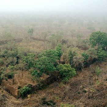
占地1萬1130平方公尺的此處,是布吉納法索首座世界遺產地,其壯闊的石牆乃是洛比地區10座堡壘中保存最好的一處,也是泛撒哈拉地帶過去黃金貿易所帶來的強盛力量之最佳明證。位於象牙海岸、迦納與多哥等國邊界地帶的此處遺址,距今至少有千年之久。當地的聚落曾被洛朗或寇朗哥族所佔領,他們在14到17世紀之間達到勢力發展的顛峰,控制了此地區的黃金提煉與交易。縈繞在此地的許多傳奇,大部分都仍有待進一步的發掘。目前關於此處遺產地的資料仍少,不過這些聚落看來在悠長歷史中的某些時期曾經被居民離棄數次,最後則在19世紀初葉被荒廢至今。
The 11,130m2 property, the first to be inscribed in the country, with its imposing stone walls is the best preserved of ten fortresses in the Lobi area and is part of a larger group of 100 stone enclosures that bear testimony to the power of the trans-Saharan gold trade. Situated near the borders of Côte d’Ivoire, Ghana and Togo, the ruins have recently been shown to be at least 1,000 years old. The settlement was occupied by the Lohron or Koulango peoples, who controlled the extraction and transformation of gold in the region when it reached its apogee from the 14th to the 17th century. Much mystery surrounds this site large parts of which have yet to be excavated. The settlement seems to have been abandoned during some periods during its long history. The property which was finally deserted in the early 19th century is expected to yield much more information.
☆☆☆☆☆☆☆☆
遺產地小檔案
洛羅派尼遺址 The Ruins of Loropéni
所在國:布吉納法索
登錄年度:2009
占地面積:1.1130公頃
緩 衝 區:278.4000公頃
座落位置:北緯10度15分00秒,西經03度34分60秒
遺產編號:1225rev
適用標準:(iii)
遺產地連結:http://whc.unesco.org/en/list/1225/


 留言列表
留言列表
